![](/images/other/stat-length.png)
![Tour Zu Fuß Le Frasnois - Les 4 lacs - Photo](https://media.geolcdn.com/t/1900/400/ca314e38-1257-4deb-9ccf-5eac74f886c4.jpg&format=pjpeg&maxdim=2)
Les 4 lacs
Au fil de nos découvertes
« L’heure de la fin des découvertes ne sonne jamais. » Colette GUIDE+
![Länge](/images/other/stat-length.png)
![Maximale Höhe](https://static1.geolcdn.com/siteimages/upload/files/1508320355ic_sort_altitude_max_24dp.png)
![Positive Höhendifferenz](https://static1.geolcdn.com/siteimages/upload/files/1508320355ic_sort_den_pos_24dp.png)
![Km-Effort](/images/other/stat-length.png)
![Min. Höhe](https://static1.geolcdn.com/siteimages/upload/files/1508320355ic_sort_altitude_min_24dp.png)
![Negative Höhendifferenz](https://static1.geolcdn.com/siteimages/upload/files/1508320355ic_sort_den_neg_24dp.png)
![Boucle](https://static1.geolcdn.com/siteimages/upload/files/16400158638029165_repeat_loop_refresh_sync_direction_icon.png)
![Zu Fuß](https://static1.geolcdn.com/sitytour/trail-icons/100.png)
4h14
Schwierigkeit : Einfach
![Scannen Sie diesen QR-Code, um die Tour in der SityTrail-Anwendung zu öffnen](https://capi.geolives.com/qq0zvz2zws4bq2lad0pu/sitytour/trails/3031117/qr.png?size=200)
Kostenlosegpshiking-Anwendung
Über SityTrail
Tour Zu Fuß von 13,5 km verfügbar auf Burgund und Freigrafschaft, Jura, Le Frasnois. Diese Tour wird von Au fil de nos découvertes vorgeschlagen.
Beschreibung
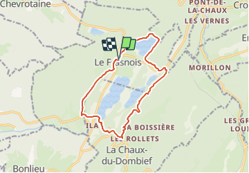
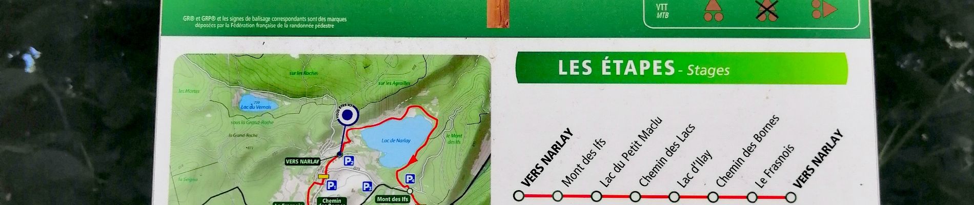
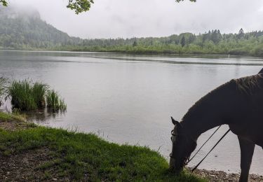
Tour des 4 lacs – Le Frasnois dans le Jura.
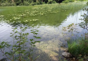
L’eau y est turquoise. C’est juste magnifique. 💦😱
🅿️ Départ et Parking: 41 Route des Lacs, 39130 Le Frasnois, France
En sortant du parking. Prendre à gauche. Et remonter le village. Suivre les balises « trait jaune » (tracé vert)
⚠️ Les balises ne sont pas toujours voyantes, ce sont des morceaux de bandes jaunes collées ou de simples traits jaunes à la peinture sur les panneaux un peu partout. Toujours longer les lacs. Le retour se fait le long de la grand route.
Il y a un endroit pour pic-niquer 🥪🥖
Chiens autorisés en laisse. 🐩🐶🐕
Convient vraiment aux enfants 🧑🧒
✅ Faites un petit détour par le Belvédère des 4 lacs. 21 Hameau des Rollets, 39150 La Chaux-du-Dombief, France
N'hésitez pas à aller faire un tour sur notre site internet et nos réseaux :
www.aufildenosdecouvertes.com
www.facebook.com/aufildenosdecouvertes
https://www.instagram.com/au_fil_de_nos_decouvertes/
Ort
Kommentare
Touren in der Umgebung
![Tour Wandern Le Frasnois - Cascades du Hérisson et les 4 lacs - Photo](https://media.geolcdn.com/t/375/260/21e4ab88-25e9-4626-96ca-824b99d2ef38.jpg&format=jpg&maxdim=2)
![Wandern Wandern](https://static1.geolcdn.com/sitytour/trail-icons/101.png)
Wandern
![](/images/other/stat-length.png)
![](https://static1.geolcdn.com/siteimages/upload/files/16400158638029165_repeat_loop_refresh_sync_direction_icon.png)
![Tour Wandern Menétrux-en-Joux - Cascades du Hérisson 13.7.24 - Photo](https://media.geolcdn.com/t/375/260/69d09d5d-3655-46aa-9437-84eed487569c.jpg&format=jpg&maxdim=2)
![Wandern Wandern](https://static1.geolcdn.com/sitytour/trail-icons/101.png)
Wandern
![](/images/other/stat-length.png)
![](https://static1.geolcdn.com/siteimages/upload/files/16400158638029165_repeat_loop_refresh_sync_direction_icon.png)
![Tour Wandern Le Frasnois - Lac de Narlay - Pic de l'Aigle - Photo](https://media.geolcdn.com/t/375/260/b7a3f0c8-5d9b-454f-b8e6-bb75ea28ecff.jpg&format=jpg&maxdim=2)
![Wandern Wandern](https://static1.geolcdn.com/sitytour/trail-icons/101.png)
Wandern
![](/images/other/stat-length.png)
![](https://static1.geolcdn.com/siteimages/upload/files/16400158638029165_repeat_loop_refresh_sync_direction_icon.png)
![Tour Wandern Le Frasnois - lacs des maclut - Photo](https://media.geolcdn.com/t/375/260/ext.jpg?maxdim=2&url=https%3A%2F%2Fstatic1.geolcdn.com%2Fsiteimages%2Fupload%2Ffiles%2F1553511878bg_sport_marche.png)
![Wandern Wandern](https://static1.geolcdn.com/sitytour/trail-icons/101.png)
Wandern
![](/images/other/stat-length.png)
![](https://static1.geolcdn.com/siteimages/upload/files/16400158638029165_repeat_loop_refresh_sync_direction_icon.png)
![Tour Wandern La Chaux-du-Dombief - pic de l''aigle - la Chaux-du-Dombief - Photo](https://media.geolcdn.com/t/375/260/ext.jpg?maxdim=2&url=https%3A%2F%2Fstatic1.geolcdn.com%2Fsiteimages%2Fupload%2Ffiles%2F1553511878bg_sport_marche.png)
![Wandern Wandern](https://static1.geolcdn.com/sitytour/trail-icons/101.png)
Wandern
![](/images/other/stat-length.png)
![](https://static1.geolcdn.com/siteimages/upload/files/16400158638029165_repeat_loop_refresh_sync_direction_icon.png)
![Tour Wandern La Chaux-du-Dombief - Pic de l'Aigle - Photo](https://media.geolcdn.com/t/375/260/c203af9d-fb05-4002-9a9b-9cbbb8532a26.jpg&format=jpg&maxdim=2)
![Wandern Wandern](https://static1.geolcdn.com/sitytour/trail-icons/101.png)
Wandern
![](/images/other/stat-length.png)
![](https://static1.geolcdn.com/siteimages/upload/files/16400158638029165_repeat_loop_refresh_sync_direction_icon.png)
![Tour Wandern Le Frasnois - La Fromagerie - Photo](https://media.geolcdn.com/t/375/260/8bf2dd93-4fc0-4bb5-bd59-9d9720fff72b.jpg&format=jpg&maxdim=2)
![Wandern Wandern](https://static1.geolcdn.com/sitytour/trail-icons/101.png)
Wandern
![](/images/other/stat-length.png)
![](https://static1.geolcdn.com/siteimages/upload/files/16400158638029165_repeat_loop_refresh_sync_direction_icon.png)
![Tour Wandern Le Frasnois - Pic de l'Aigle 14.7.24 - Photo](https://media.geolcdn.com/t/375/260/0d4fe3bb-0e43-456c-9601-a5aa0df2bf07.jpg&format=jpg&maxdim=2)
![Wandern Wandern](https://static1.geolcdn.com/sitytour/trail-icons/101.png)
Wandern
![](/images/other/stat-length.png)
![](https://static1.geolcdn.com/siteimages/upload/files/16400158638029165_repeat_loop_refresh_sync_direction_icon.png)
![Tour Reiten Le Frasnois - suuntoapp-HorsebackRiding-2024-05-22T07-07-14Z - Photo](https://media.geolcdn.com/t/375/260/02cd052f-9d06-4d04-8797-8cfd020cca6b.jpg&format=jpg&maxdim=2)
![Reiten Reiten](https://static1.geolcdn.com/sitytour/trail-icons/301.png)
Reiten
![](/images/other/stat-length.png)
![](https://static1.geolcdn.com/siteimages/upload/files/16400158638029165_repeat_loop_refresh_sync_direction_icon.png)